
Jukskei River topographic map
Interactive map
Click on the map to display elevation.
About this map
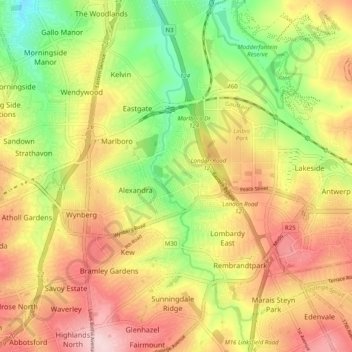
Name: Jukskei River topographic map, elevation, terrain.
Average elevation: 1,568 m
Minimum elevation: 1,446 m
Maximum elevation: 1,682 m
Other topographic maps
Click on a map to view its topography, its elevation and its terrain.
Jukskei River
Jukskei River, Sandton, City of Johannesburg Metropolitan Municipality, Gauteng, 1610, RSA
Average elevation: 1,592 m
Johannesburg Ward 74
Johannesburg Ward 74, Sandton, City of Johannesburg Metropolitan Municipality, Gauteng, RSA
Average elevation: 1,638 m
Johannesburg Ward 106
Johannesburg Ward 106, Sandton, City of Johannesburg Metropolitan Municipality, Gauteng, RSA
Average elevation: 1,473 m
Johannesburg Ward 102
Johannesburg Ward 102, Sandton, City of Johannesburg Metropolitan Municipality, Gauteng, 2125, RSA
Average elevation: 1,542 m
Johannesburg Ward 112
Johannesburg Ward 112, Sandton, City of Johannesburg Metropolitan Municipality, Gauteng, RSA
Average elevation: 1,519 m