
Helsingborg topographic map
Interactive map
Click on the map to display elevation.
About this map
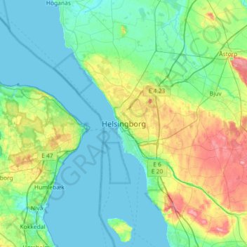
Name: Helsingborg topographic map, elevation, terrain.
Location: Helsingborg, Skåne County, Region Götaland, 252 68, Sweden (55.88420 12.54407 56.20420 12.86407)
Average elevation: 22 m
Minimum elevation: -1 m
Maximum elevation: 101 m
Other topographic maps
Click on a map to view its topography, its elevation and its terrain.
Centrum
Sweden > Skåne County > Helsingborg
Centrum, Helsingborg, Skåne County, Region Götaland, Sweden
Average elevation: 4 m