
Kullu topographic map
Interactive map
Click on the map to display elevation.
About this map
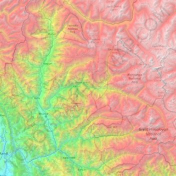
Name: Kullu topographic map, elevation, terrain.
Location: Kullu, Himachal Pradesh, India (31.78141 76.93577 32.22417 77.86770)
Average elevation: 3,631 m
Minimum elevation: 736 m
Maximum elevation: 6,496 m
Other topographic maps
Click on a map to view its topography, its elevation and its terrain.
Tosa
India > Himachal Pradesh > Chamba
Tosa, Chamba, Chamba District, Himachal Pradesh, 176319, India
Average elevation: 1,674 m
Lahul and Spiti
Lahul and Spiti, Himachal Pradesh, India
Average elevation: 4,286 m
Kullu
India > Himachal Pradesh > Kullu
Kullu, Himachal Pradesh, 175100, India
Average elevation: 1,808 m