
Big Creek topographic map
Interactive map
Click on the map to display elevation.
About this map
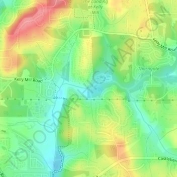
Name: Big Creek topographic map, elevation, terrain.
Location: Big Creek, Forsyth County, Georgia, 300410, USA (34.19885 -84.18039 34.19889 -84.17960)
Average elevation: 348 m
Minimum elevation: 311 m
Maximum elevation: 398 m
Other topographic maps
Click on a map to view its topography, its elevation and its terrain.
Stone Mountain
Stone Mountain, DeKalb County, Georgia, 30087, USA
Average elevation: 299 m
Cameron Point
USA > Georgia > Cameron Point
Cameron Point, Hall County, Georgia, 30506:30534, USA
Average elevation: 339 m
Ferrell Crossroads
USA > Georgia > Ferrell Crossroads
Ferrell Crossroads, Early County, Georgia, USA
Average elevation: 94 m