
Kenton County topographic map
Interactive map
Click on the map to display elevation.
About this map
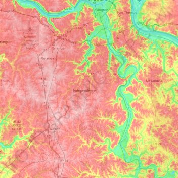
Name: Kenton County topographic map, elevation, terrain.
Location: Kenton County, Kentucky, USA (38.78992 -84.62370 39.09992 -84.41749)
Average elevation: 233 m
Minimum elevation: 135 m
Maximum elevation: 293 m
Other topographic maps
Click on a map to view its topography, its elevation and its terrain.
Tigers
USA > Kentucky > Louisville
Tigers, Louisville, Jefferson County, Kentucky, USA
Average elevation: 155 m
Shelbyville
USA > Kentucky > Shelbyville
Shelbyville, Shelby County, Kentucky, 40065, USA
Average elevation: 232 m
Georgetown
USA > Kentucky > Georgetown
Georgetown, Scott County, Kentucky, 40324, USA
Average elevation: 265 m
Murray Hill
USA > Kentucky > Murray Hill
Murray Hill, Jefferson County, Kentucky, USA
Average elevation: 194 m
Mammoth Cave
USA > Kentucky > Mammoth Cave
Mammoth Cave, Edmonson County, Kentucky, USA
Average elevation: 214 m