Geolocate

Traill-iup Immikkeertivi topographic map

Interactive map

Click on the map to display elevation.

About this map

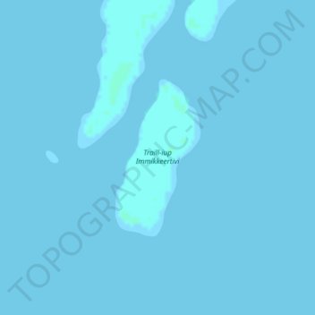
Name: Traill-iup Immikkeertivi topographic map, elevation, terrain.

Location: Traill-iup Immikkeertivi, Sermersooq, Greenland (72.43944 -24.10127 72.45291 -24.07700)

Average elevation: 0 m

Minimum elevation: -1 m

Maximum elevation: 2 m

Other topographic maps

Click on a map to view its topography, its elevation and its terrain.

Qeqqata

Greenland

Qeqqata, Greenland

Average elevation: 1,504 m

Qaasuitsup

Greenland > Avannaata

Qaasuitsup, Avannaata, Greenland

Average elevation: 1,344 m

Sermersooq

Greenland

Sermersooq, Greenland

Average elevation: 1,116 m

Kujalleq

Greenland

Kujalleq, Greenland

Average elevation: 784 m

Pyramid

Greenland

Pyramid, Sermersooq, Greenland

Average elevation: 2,097 m

Geographical Society Island

Greenland

Geographical Society Island, Sermersooq, Greenland

Average elevation: 178 m

Karale Glacier

Greenland

Karale Glacier, Sermersooq, Greenland

Average elevation: 602 m

Helheim Glacier

Greenland

Helheim Glacier, Sermersooq, Greenland

Average elevation: 147 m

Store Koldewey

Greenland

Store Koldewey, Sermersooq, Greenland

Average elevation: 40 m

Greenland ice sheet

Greenland

Greenland ice sheet, Sermersooq, Greenland

Average elevation: 796 m

Shannon Island

Greenland

Shannon Island, Sermersooq, Greenland

Average elevation: 18 m

Frederikshaab Glacier

Greenland

Frederikshaab Glacier, Sermersooq, Greenland

Average elevation: 340 m

Gunnbjørn Fjeld

Greenland

Gunnbjørn Fjeld, Sermersooq, Greenland

Average elevation: 3,251 m

Milne Land

Greenland

Milne Land, Sermersooq, Greenland

Average elevation: 39 m