
Thailand topographic map
Interactive map
Click on the map to display elevation.
About this map
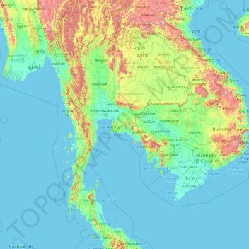
Name: Thailand topographic map, elevation, terrain.
Location: Thailand (5.61285 97.34381 20.46483 105.63681)
Average elevation: 156 m
Minimum elevation: -3 m
Maximum elevation: 2,557 m
Thailand comprises several distinct geographic regions, partly corresponding to the provincial groups. The north of the country is the mountainous area of the Thai highlands, with the highest point being Doi Inthanon in the Thanon Thong Chai Range at 2,565 metres (8,415 ft) elevation. The northeast, Isan, consists of the Khorat Plateau, bordered to the east by the Mekong River. The centre of the country is dominated by the predominantly flat Chao Phraya river valley, which runs into the Gulf of Thailand.
Other topographic maps
Click on a map to view its topography, its elevation and its terrain.
Chiang Mai
Thailand > Chiang Mai Province
Chiang Mai, Pa Daet, Saraphi District, Chiang Mai Province, 55520, Thailand
Average elevation: 424 m
Maha Phram Subdistrict Municipality
Thailand > Phra Nakhon Si Ayutthaya Province > Bang Ban District
Maha Phram Subdistrict Municipality, Bang Ban District, Phra Nakhon Si Ayutthaya Province, 13250, Thailand
Average elevation: 5 m
Kathu
Thailand > Phuket Province > Kathu
Kathu, Phuket Province, 83120, Thailand
Average elevation: 133 m
Hua Dong
Thailand > Phichit Province > Hua Dong
Hua Dong, Phichit Province, Thailand
Average elevation: 35 m
Chom Thong District
Chom Thong District, Bangkok, 10150, Thailand
Average elevation: 5 m
Aiyoeweng-Sea Of Mist
Aiyoeweng-Sea Of Mist, Sukkhayang Road, Yala Province, Thailand
Average elevation: 355 m
Nakhon Si Thammarat Province
Thailand > Nakhon Si Thammarat Province
Nakhon Si Thammarat Province, Thailand
Average elevation: 28 m
Chachoengsao Province
Thailand > Chachoengsao Province
Chachoengsao Province, Thailand
Average elevation: 142 m
Kaeng Krachan
Thailand > Phetchaburi Province > Kaeng Krachan
Kaeng Krachan, Phetchaburi Province, 76170, Thailand
Average elevation: 95 m
Ban Nong Na Dam
Thailand > Phichit Province > Ban Nong Na Dam
Ban Nong Na Dam, Phichit Province, Thailand
Average elevation: 37 m
Baan Klong Son
Thailand > Trat Province > Baan Klong Son
Baan Klong Son, Trat Province, Thailand
Average elevation: 55 m
Doi Pha Hom Pok National Park
Thailand > Chiang Mai Province > Ban Huey Mak Liam
Doi Pha Hom Pok National Park, ชม.3015, Ban Huey Mak Liam, Chiang Mai Province, Thailand
Average elevation: 847 m
Nakhon Sawan
Thailand > Nakhon Sawan Province > Nakhon Sawan
Nakhon Sawan, Nakhon Sawan Province, 60000, Thailand
Average elevation: 34 m
Khao luang
Thailand > Nakhon Si Thammarat Province > Nakhon Si Thammarat
Khao luang, Nakhon Si Thammarat, Nakhon Si Thammarat Province, Thailand
Average elevation: 1,286 m
Big Kathu
Thailand > Phuket Province > Phuket
Big Kathu, Phuket, Phuket Province, 83120, Thailand
Average elevation: 237 m
Laem Pho
Thailand > Krabi Province > Haad Yao
Laem Pho, Haad Yao, Krabi Province, Thailand
Average elevation: 8 m
Pattani
Pattani, Ru Samilae, Pattani Province, 94000, Thailand
Average elevation: 3 m