
Make a donation
Mbombela (Nelspruit) topographic map
Click on the map to display elevation.
Make a donation
About this map
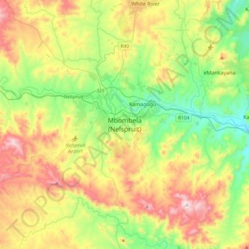
Name: Mbombela (Nelspruit) topographic map, elevation, terrain.
Average elevation: 842 m
Minimum elevation: 493 m
Maximum elevation: 1,483 m
Make a donation
Other topographic maps
Click on a map to view its topography, its elevation and its terrain.
Witklip Dam
South Africa > Mpumalanga > Ehlanzeni District Municipality > Thaba Chweu Local Municipality
Average elevation: 1,048 m
Manyeleti
South Africa > Mpumalanga > Ehlanzeni District Municipality > Bushbuckridge
Average elevation: 376 m
Make a donation
Thaba Chweu Local Municipality
South Africa > Mpumalanga > Ehlanzeni District Municipality
Average elevation: 1,207 m
Longmere Dam
South Africa > Mpumalanga > Ehlanzeni District Municipality > Mbombela > White River Country Estates
Average elevation: 963 m
Kwena Dam
South Africa > Mpumalanga > Ehlanzeni District Municipality > Thaba Chweu Local Municipality
Average elevation: 1,185 m
Thaba Chweu Local Municipality
South Africa > Mpumalanga > Ehlanzeni District Municipality
Average elevation: 1,207 m
Make a donation
Lydenburg
South Africa > Mpumalanga > Ehlanzeni District Municipality > Thaba Chweu Local Municipality
Average elevation: 1,424 m
Umjindi Local Municipality
South Africa > Mpumalanga > Ehlanzeni District Municipality
Average elevation: 1,007 m
Umjindi Ward 1
South Africa > Mpumalanga > Ehlanzeni District Municipality > Umjindi Local Municipality
Average elevation: 916 m
Make a donation
Umbabat Nature Reserve
South Africa > Mpumalanga > Ehlanzeni District Municipality > Bushbuckridge
Average elevation: 343 m
Manyeleti
South Africa > Mpumalanga > Ehlanzeni District Municipality > Bushbuckridge
Average elevation: 376 m
Blyde River
South Africa > Mpumalanga > Ehlanzeni District Municipality
The Motlatse River ("Permanent River"), Blyde River (Afrikaans: Blyderivier "Glad River"), or Umdhlazi River is a river in the Mpumalanga and Limpopo provinces of South Africa. It has a northwards course in steep-sided valleys and ravines of the Mpumalanga Drakensberg, before it enters the lowveld region of…
Average elevation: 930 m
Make a donation
Driekoppies Dam
South Africa > Mpumalanga > Ehlanzeni District Municipality > Nkomazi > Schulzendal
Average elevation: 355 m
Marite
South Africa > Mpumalanga > Ehlanzeni District Municipality > Bushbuckridge
Average elevation: 602 m
MalaMala Game Reserve
South Africa > Mpumalanga > Ehlanzeni District Municipality > Bushbuckridge
Average elevation: 338 m
Kwena Dam
South Africa > Mpumalanga > Ehlanzeni District Municipality > Thaba Chweu Local Municipality
Average elevation: 1,185 m
Make a donation
Tekwane North
South Africa > Mpumalanga > Ehlanzeni District Municipality > Mbombela > eMankayana
Average elevation: 771 m
MalaMala Game Reserve
South Africa > Mpumalanga > Ehlanzeni District Municipality > Bushbuckridge
Average elevation: 338 m
Thaba Chweu Local Municipality
South Africa > Mpumalanga > Ehlanzeni District Municipality
Average elevation: 1,207 m
Make a donation
Lydenburg
South Africa > Mpumalanga > Ehlanzeni District Municipality > Thaba Chweu Local Municipality
Average elevation: 1,424 m
Blyde River Canyon Nature Reserve
South Africa > Mpumalanga > Ehlanzeni District Municipality > Thaba Chweu Local Municipality
The Mogologolo (1,794 m), Mariepskop (1,944 m) and Hebronberg (1,767 m) massifs are partially included in the reserve. Elevation varies from 560 m to 1,944 m above sea level. Its resort areas are F.H. Odendaal and Swadeni, the latter only accessible from Limpopo province. The area of approximately 29,000…
Average elevation: 1,040 m
Klipkoppie Dam
South Africa > Mpumalanga > Ehlanzeni District Municipality > Mbombela
Average elevation: 973 m
Make a donation
Klaserie Private Nature Reserve
South Africa > Mpumalanga > Ehlanzeni District Municipality
Average elevation: 395 m
Thaba Chweu Local Municipality
South Africa > Mpumalanga > Ehlanzeni District Municipality
Average elevation: 1,207 m