
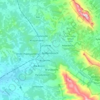
Stellenbosch topographic map
Interactive map
Click on the map to display elevation.
About this map
Name: Stellenbosch topographic map, elevation, terrain.
Average elevation: 287 m
Minimum elevation: 36 m
Maximum elevation: 1,364 m
Stellenbosch is 53 km (33 mi) east of Cape Town via National Route N1. Stellenbosch is in a hilly region of the Cape Winelands, and is sheltered in a valley at an average elevation of 136 m (446 ft), flanked on the west by Papegaaiberg (Afrikaans: Parrot Mountain), which is actually a hill. To the south is Stellenbosch Mountain; to the east and southeast are the Jonkershoek, Drakenstein, and Simonsberg mountains. Die Tweeling Pieke (Afrikaans: The Twin Peaks) has an elevation of 1,494 m (4,902 ft); the highest point is Victoria Peak 1,590 m (5,220 ft). Jonkershoek Nature Reserve lies about 9 km (5.6 mi) east of Stellenbosch, and the Helderberg Nature Reserve is about 23 km (14 mi) south via provincial route R44. Just south of the Helderberg Nature Reserve is Strand, a seaside resort town. The soils of Stellenbosch range from dark alluvium to clay. This, combined with the well-drained, hilly terrain and Mediterranean climate, prove excellent for viticulture. Summers are dry and warm to hot, with some February and March days rising to over 40 °C (104 °F). Winters are cool, rainy and sometimes quite windy, with daytime temperatures averaging 16 °C (61 °F). Snow is usually seen a couple of times in winter on the surrounding mountains. Spring and autumn are colder seasons, when daytime temperatures hover in the 20s.
Other topographic maps
Click on a map to view its topography, its elevation and its terrain.
Franschhoek
South Africa > Western Cape > Cape Winelands District Municipality > Stellenbosch Local Municipality
Franschhoek, Stellenbosch Local Municipality, Cape Winelands District Municipality, Western Cape, 7690, South Africa
Average elevation: 502 m
La Motte
South Africa > Western Cape > Cape Winelands District Municipality > Stellenbosch Local Municipality
La Motte, Stellenbosch Ward 3, Stellenbosch Local Municipality, Cape Winelands District Municipality, Western Cape, South Africa
Average elevation: 315 m
Groot-Drakenstein
South Africa > Western Cape > Cape Winelands District Municipality > Stellenbosch Local Municipality
Groot-Drakenstein, Stellenbosch Local Municipality, Cape Winelands District Municipality, Western Cape, 7680, South Africa
Average elevation: 173 m
Driekop
South Africa > Western Cape > Cape Winelands District Municipality > Stellenbosch Local Municipality
Driekop, Stellenbosch Local Municipality, Cape Winelands District Municipality, Western Cape, South Africa
Average elevation: 557 m
MTO Jonkershoek
South Africa > Western Cape > Cape Winelands District Municipality > Stellenbosch Local Municipality
MTO Jonkershoek, Jonkershoek Road, Stellenbosch Ward 5, Stellenbosch Local Municipality, Cape Winelands District Municipality, Western Cape, South Africa
Average elevation: 522 m
Groendal
South Africa > Western Cape > Cape Winelands District Municipality > Stellenbosch Local Municipality > Groendal
Groendal, Stellenbosch Local Municipality, Cape Winelands District Municipality, Western Cape, 7690, South Africa
Average elevation: 353 m
Berg River Dam
South Africa > Western Cape > Cape Winelands District Municipality > Stellenbosch Local Municipality
Berg River Dam, Stellenbosch Local Municipality, Cape Winelands District Municipality, Western Cape, South Africa
Average elevation: 376 m
Klapmuts
South Africa > Western Cape > Cape Winelands District Municipality > Stellenbosch Local Municipality
Klapmuts, Stellenbosch Local Municipality, Cape Winelands District Municipality, Western Cape, South Africa
Average elevation: 186 m