
Make a donation
Port Shepstone topographic map
Click on the map to display elevation.
Make a donation
Port Shepstone
Port Shepstone's topography is characterised by a rugged/hilly terrain with the Central Business District (CBD) lying on a large hill overlooking the Indian Ocean. Port Shepstone proper (excluding its extensions) is bordered by the uMzimkhulu River to the north and the N2 freeway to the east and is also bordered by its extensions of Umtentweni to the north, Oslo Beach to the south and Marburg to the west.
Make a donation
About this map
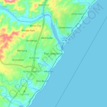
Name: Port Shepstone topographic map, elevation, terrain.
Average elevation: 33 m
Minimum elevation: -4 m
Maximum elevation: 203 m
Make a donation
Other topographic maps
Click on a map to view its topography, its elevation and its terrain.
Umzimkulu River
South Africa > KwaZulu-Natal > Ugu District Municipality > Hibiscus Coast Local Municipality > Port Shepstone
Average elevation: 135 m
Ivy Beach
South Africa > KwaZulu-Natal > Ugu District Municipality > Hibiscus Coast Local Municipality > Leisure Bay > Ivy Beach
Average elevation: 21 m