
De Aar topographic map
Interactive map
Click on the map to display elevation.
About this map
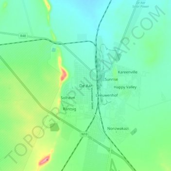
Name: De Aar topographic map, elevation, terrain.
Average elevation: 1,257 m
Minimum elevation: 1,217 m
Maximum elevation: 1,378 m
Other topographic maps
Click on a map to view its topography, its elevation and its terrain.
Emthanjeni Ward 7
South Africa > Northern Cape > Pixley ka Seme District Municipality > Emthanjeni Local Municipality
Emthanjeni Ward 7, Emthanjeni Local Municipality, Pixley ka Seme District Municipality, Northern Cape, 8782, South Africa
Average elevation: 1,172 m
Emthanjeni Local Municipality
South Africa > Northern Cape > Pixley ka Seme District Municipality > Emthanjeni Local Municipality
Emthanjeni Local Municipality, Pixley ka Seme District Municipality, Northern Cape, South Africa
Average elevation: 1,259 m
Britstown
South Africa > Northern Cape > Pixley ka Seme District Municipality > Emthanjeni Local Municipality
Britstown, Emthanjeni Local Municipality, Pixley ka Seme District Municipality, Northern Cape, 8782, South Africa
Average elevation: 1,130 m