
Make a donation
Vereeniging topographic map
Click on the map to display elevation.
Make a donation
About this map
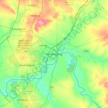
Name: Vereeniging topographic map, elevation, terrain.
Average elevation: 1,475 m
Minimum elevation: 1,408 m
Maximum elevation: 1,617 m
Make a donation
Other topographic maps
Click on a map to view its topography, its elevation and its terrain.
Midvaal Local Municipality
South Africa > Gauteng > Sedibeng District Municipality
Average elevation: 1,531 m
Midvaal Local Municipality
South Africa > Gauteng > Sedibeng District Municipality
Average elevation: 1,531 m
Emfuleni Local Municipality
South Africa > Gauteng > Sedibeng District Municipality
Average elevation: 1,501 m
Modderfontein
South Africa > Gauteng > Sedibeng District Municipality > Midvaal Local Municipality
Average elevation: 1,534 m
Make a donation
SE8
South Africa > Gauteng > Sedibeng District Municipality > Emfuleni Local Municipality
Average elevation: 1,456 m
Suikerbosrand Nature Reserve
South Africa > Gauteng > Sedibeng District Municipality > Lesedi Local Municipality
Suikerbosrand Nature Reserve is a protected area which encompasses most of the Suikerbosrand Range, South Africa. It is one of Gauteng's most frequented ecotourism locations, located approximately 50 kilometres south-east of Johannesburg, just west of the town of Heidelberg in the upper catchment of the Klip…
Average elevation: 1,617 m
Bass Lake
South Africa > Gauteng > Sedibeng District Municipality > Midvaal Local Municipality
Average elevation: 1,473 m
Sharpeville
South Africa > Gauteng > Sedibeng District Municipality > Emfuleni Local Municipality
Average elevation: 1,459 m
Make a donation
Sharpeville
South Africa > Gauteng > Sedibeng District Municipality > Emfuleni Local Municipality
Average elevation: 1,459 m
SE10
South Africa > Gauteng > Sedibeng District Municipality > Emfuleni Local Municipality
Average elevation: 1,462 m
Modderfontein
South Africa > Gauteng > Sedibeng District Municipality > Midvaal Local Municipality
Average elevation: 1,534 m
Make a donation
Emfuleni Local Municipality
South Africa > Gauteng > Sedibeng District Municipality
Average elevation: 1,501 m
Sharpeville
South Africa > Gauteng > Sedibeng District Municipality > Emfuleni Local Municipality
Average elevation: 1,459 m
Boipatong
South Africa > Gauteng > Sedibeng District Municipality > Emfuleni Local Municipality
Average elevation: 1,478 m
CW2
South Africa > Gauteng > Sedibeng District Municipality > Emfuleni Local Municipality
Average elevation: 1,501 m
Make a donation
Boipatong
South Africa > Gauteng > Sedibeng District Municipality > Emfuleni Local Municipality
Average elevation: 1,478 m
Emfuleni Local Municipality
South Africa > Gauteng > Sedibeng District Municipality
Average elevation: 1,501 m
Lesedi Local Municipality
South Africa > Gauteng > Sedibeng District Municipality
Average elevation: 1,613 m
Midvaal Local Municipality
South Africa > Gauteng > Sedibeng District Municipality
Average elevation: 1,531 m
Make a donation
Emfuleni Local Municipality
South Africa > Gauteng > Sedibeng District Municipality
Average elevation: 1,501 m
SE1
South Africa > Gauteng > Sedibeng District Municipality > Emfuleni Local Municipality
Average elevation: 1,480 m