
Springbok topographic map
Interactive map
Click on the map to display elevation.
About this map
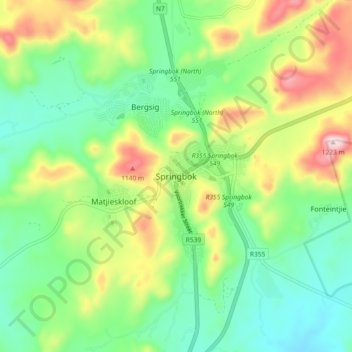
Name: Springbok topographic map, elevation, terrain.
Average elevation: 927 m
Minimum elevation: 768 m
Maximum elevation: 1,228 m
Other topographic maps
Click on a map to view its topography, its elevation and its terrain.
Concordia
South Africa > Northern Cape > Namakwa District Municipality > Nama Khoi Local Municipality
Concordia, Nama Khoi Local Municipality, Namakwa District Municipality, Northern Cape, South Africa
Average elevation: 1,033 m
Steinkopf
South Africa > Northern Cape > Namakwa District Municipality > Nama Khoi Local Municipality
Steinkopf, Nama Khoi Local Municipality, Namakwa District Municipality, Northern Cape, South Africa
Average elevation: 860 m
Nama Khoi Ward 1
South Africa > Northern Cape > Namakwa District Municipality > Nama Khoi Local Municipality
Nama Khoi Ward 1, Nama Khoi Local Municipality, Namakwa District Municipality, Northern Cape, South Africa
Average elevation: 832 m