
Thank you for supporting this site ❤️
Make a donation
Make a donation
Dullstroom topographic map
Click on the map to display elevation.
Thank you for supporting this site ❤️
Make a donation
Make a donation
Dullstroom
Due to its high elevation (Dullstroom being the highest town in South Africa itself), Dullstroom has a subtropical highland climate (Köppen: Cwb). From October to April, the town sees a significant amount of rainfall (higher than nearby Johannesburg to the west), in contrast with winter, where precipitation lacks.
Thank you for supporting this site ❤️
Make a donation
Make a donation
About this map
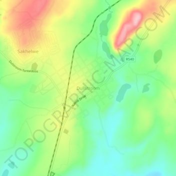
Name: Dullstroom topographic map, elevation, terrain.
Average elevation: 2,009 m
Minimum elevation: 1,939 m
Maximum elevation: 2,112 m
Thank you for supporting this site ❤️
Make a donation
Make a donation
Other topographic maps
Click on a map to view its topography, its elevation and its terrain.
Emgwenya (Waterval Boven)
South Africa > Mpumalanga > Nkangala > Emakhazeni Local Municipality
Average elevation: 1,424 m
Emakhazeni Local Municipality
South Africa > Mpumalanga > Nkangala > Emakhazeni Local Municipality
Average elevation: 1,579 m