
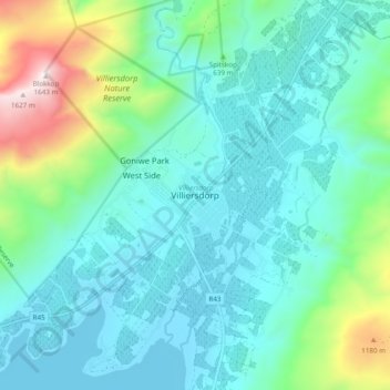
Villiersdorp topographic map
Interactive map
Click on the map to display elevation.
About this map
Name: Villiersdorp topographic map, elevation, terrain.
Average elevation: 570 m
Minimum elevation: 304 m
Maximum elevation: 1,641 m
Other topographic maps
Click on a map to view its topography, its elevation and its terrain.
Steenboksberg
South Africa > Western Cape > Overberg District Municipality > Theewaterskloof Local Municipality
Steenboksberg, Theewaterskloof Local Municipality, Overberg District Municipality, Western Cape, South Africa
Average elevation: 469 m
Witklip Dam
South Africa > Western Cape > Overberg District Municipality > Theewaterskloof Local Municipality
Witklip Dam, Theewaterskloof Ward 5, Theewaterskloof Local Municipality, Overberg District Municipality, Western Cape, South Africa
Average elevation: 687 m
Swartberg
South Africa > Western Cape > Overberg District Municipality > Theewaterskloof Local Municipality
Swartberg, Theewaterskloof Local Municipality, Overberg District Municipality, Western Cape, South Africa
Average elevation: 852 m
Grabouw
South Africa > Western Cape > Overberg District Municipality > Theewaterskloof Local Municipality
Grabouw, Theewaterskloof Local Municipality, Overberg District Municipality, Western Cape, South Africa
Average elevation: 358 m
Caledon
South Africa > Western Cape > Overberg District Municipality > Theewaterskloof Local Municipality
Caledon, Theewaterskloof Local Municipality, Overberg District Municipality, Western Cape, 7230, South Africa
Average elevation: 311 m
Bot River
South Africa > Western Cape > Overberg District Municipality > Theewaterskloof Local Municipality
Bot River, Theewaterskloof Local Municipality, Overberg District Municipality, Western Cape, South Africa
Average elevation: 306 m
Tesselaarsdal
South Africa > Western Cape > Overberg District Municipality > Theewaterskloof Local Municipality
Tesselaarsdal, Theewaterskloof Local Municipality, Overberg District Municipality, Western Cape, South Africa
Average elevation: 273 m