
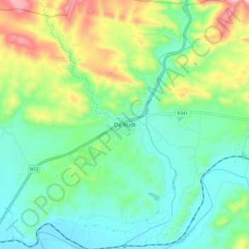
De Rust topographic map
Interactive map
Click on the map to display elevation.
About this map
Name: De Rust topographic map, elevation, terrain.
Average elevation: 544 m
Minimum elevation: 381 m
Maximum elevation: 936 m
Other topographic maps
Click on a map to view its topography, its elevation and its terrain.
Dysselsdorp
South Africa > Western Cape > Garden Route District Municipality > Oudtshoorn Local Municipality
Dysselsdorp, Oudtshoorn Local Municipality, Garden Route District Municipality, Western Cape, South Africa
Average elevation: 439 m
Cango
South Africa > Western Cape > Garden Route District Municipality > Oudtshoorn Local Municipality
Cango, Oudtshoorn Local Municipality, Garden Route District Municipality, Western Cape, South Africa
Average elevation: 587 m
Swartberg Pass
South Africa > Western Cape > Garden Route District Municipality > Oudtshoorn Local Municipality
Swartberg Pass, Oudtshoorn Ward 2, Oudtshoorn Local Municipality, Garden Route District Municipality, Western Cape, South Africa
Average elevation: 1,462 m
Fouriesberg
South Africa > Western Cape > Garden Route District Municipality > Oudtshoorn Local Municipality
Fouriesberg, Oudtshoorn Local Municipality, Garden Route District Municipality, Western Cape, South Africa
Average elevation: 778 m