
uMhlangane River topographic map
Interactive map
Click on the map to display elevation.
About this map
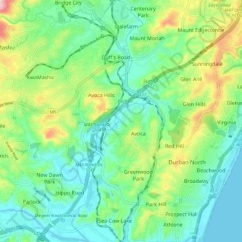
Name: uMhlangane River topographic map, elevation, terrain.
Average elevation: 65 m
Minimum elevation: 0 m
Maximum elevation: 222 m
Other topographic maps
Click on a map to view its topography, its elevation and its terrain.
uMhlangane River
South Africa > KwaZulu-Natal > eThekwini Metropolitan Municipality > KwaMashu
uMhlangane River, KwaMashu, eThekwini Metropolitan Municipality, KwaZulu-Natal, 4360, South Africa
Average elevation: 95 m