
Hill of Glendye topographic map
Interactive map
Click on the map to display elevation.
About this map
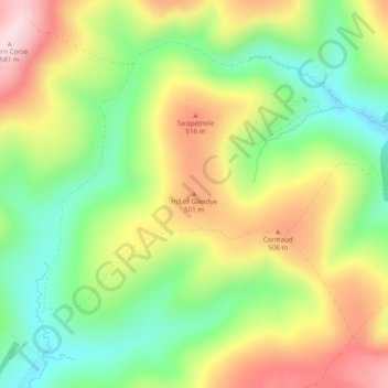
Name: Hill of Glendye topographic map, elevation, terrain.
Location: Hill of Glendye, Angus, Scotland, DD8 5JS, United Kingdom (56.75461 -3.14764 56.75471 -3.14754)
Average elevation: 416 m
Minimum elevation: 284 m
Maximum elevation: 580 m
Other topographic maps
Click on a map to view its topography, its elevation and its terrain.
Greystone
United Kingdom > Scotland > Angus
Greystone, Angus, Scotland, DD11 2RJ, United Kingdom
Average elevation: 162 m
Elliot
United Kingdom > Scotland > Angus > Arbroath
Elliot, Arbroath, Angus, Scotland, DD11 2PE, United Kingdom
Average elevation: 17 m