
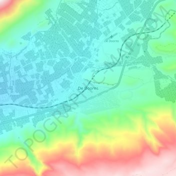
De Doorns topographic map
Interactive map
Click on the map to display elevation.
About this map
Name: De Doorns topographic map, elevation, terrain.
Average elevation: 683 m
Minimum elevation: 409 m
Maximum elevation: 1,457 m
Other topographic maps
Click on a map to view its topography, its elevation and its terrain.
Worcester
South Africa > Western Cape > Cape Winelands District Municipality > Breede Valley Local Municipality
Worcester, Breede Valley Local Municipality, Cape Winelands District Municipality, Western Cape, 6849, South Africa
Average elevation: 252 m
Touws River
South Africa > Western Cape > Cape Winelands District Municipality > Breede Valley Local Municipality
Touws River, Breede Valley Local Municipality, Cape Winelands District Municipality, Western Cape, South Africa
Average elevation: 822 m
Matroos
South Africa > Western Cape > Cape Winelands District Municipality > Breede Valley Local Municipality
Matroos, Breede Valley Ward 3, Breede Valley Local Municipality, Cape Winelands District Municipality, Western Cape, South Africa
Average elevation: 1,642 m
Rawsonville
South Africa > Western Cape > Cape Winelands District Municipality > Breede Valley Local Municipality > Rawsonville
Rawsonville, Breede Valley Local Municipality, Cape Winelands District Municipality, Western Cape, South Africa
Average elevation: 231 m