
Crossways topographic map
Interactive map
Click on the map to display elevation.
About this map
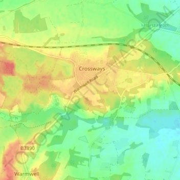
Name: Crossways topographic map, elevation, terrain.
Location: Crossways, Dorset, South West England, England, United Kingdom (50.68113 -2.36026 50.70172 -2.29662)
Average elevation: 46 m
Minimum elevation: 23 m
Maximum elevation: 72 m
Other topographic maps
Click on a map to view its topography, its elevation and its terrain.
Dorchester
United Kingdom > England > Dorset
Dorchester, Dorset, England, United Kingdom
Average elevation: 72 m
Broadwindsor
United Kingdom > England > Dorset
Broadwindsor, Dorset, England, United Kingdom
Average elevation: 128 m
Bryanston
United Kingdom > England > Dorset
Bryanston, Dorset, England, United Kingdom
Average elevation: 92 m