
uPhongolo Ward 14 topographic map
Interactive map
Click on the map to display elevation.
About this map
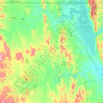
Name: uPhongolo Ward 14 topographic map, elevation, terrain.
Average elevation: 331 m
Minimum elevation: 104 m
Maximum elevation: 924 m
Other topographic maps
Click on a map to view its topography, its elevation and its terrain.
Ithala Game Reserve
RSA > KwaZulu-Natal > uPhongolo Local Municipality
Ithala Game Reserve, Dakeneni Loop, uPhongolo Ward 1, uPhongolo Local Municipality, Zululand District Municipality, KwaZulu-Natal, RSA
Average elevation: 809 m
Phongolapoort Nature Reserve
RSA > KwaZulu-Natal > uPhongolo Local Municipality
Phongolapoort Nature Reserve, uPhongolo Ward 14, uPhongolo Local Municipality, Zululand District Municipality, KwaZulu-Natal, RSA
Average elevation: 257 m