
Assegaai River topographic map
Interactive map
Click on the map to display elevation.
About this map
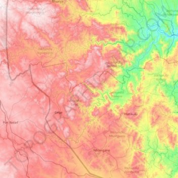
Name: Assegaai River topographic map, elevation, terrain.
Location: Assegaai River, Shiselweni, Eswatini (-27.10584 30.68168 -26.65076 31.44666)
Average elevation: 963 m
Minimum elevation: 268 m
Maximum elevation: 1,554 m
Other topographic maps
Click on a map to view its topography, its elevation and its terrain.
Gugulethu
Eswatini > Shiselweni > Inkhundla Hosea
Gugulethu, Inkhundla Hosea, Shiselweni, Eswatini
Average elevation: 499 m
Eskhaleni
Eswatini > Shiselweni > Inkhundla Somntongo
Eskhaleni, Inkhundla Somntongo, Shiselweni, Eswatini
Average elevation: 210 m