
Dudh Pokhari topographic map
Interactive map
Click on the map to display elevation.
About this map
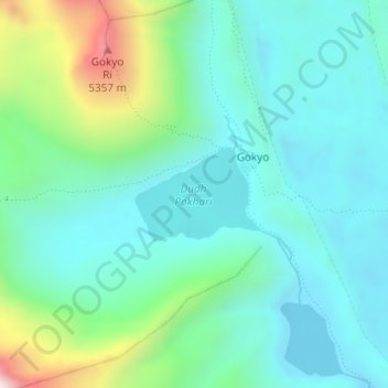
Name: Dudh Pokhari topographic map, elevation, terrain.
Average elevation: 4,878 m
Minimum elevation: 4,702 m
Maximum elevation: 5,475 m
Other topographic maps
Click on a map to view its topography, its elevation and its terrain.
Island Peak
Nepal > Eastern Development Region > Khumjung
Island Peak, Khumjung, Solukhumbu, Sagarmatha, Eastern Development Region, Nepal
Average elevation: 5,461 m
Lhotse Shar
Nepal > Eastern Development Region > Khumjung
Lhotse Shar, Khumjung, Solukhumbu, Sagarmatha, Eastern Development Region, Nepal
Average elevation: 7,153 m