
Hex River topographic map
Interactive map
Click on the map to display elevation.
About this map
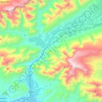
Name: Hex River topographic map, elevation, terrain.
Average elevation: 835 m
Minimum elevation: 255 m
Maximum elevation: 2,066 m
Other topographic maps
Click on a map to view its topography, its elevation and its terrain.
Riviersonderend Nature Reserve
RSA > Western Cape > Breede Valley Local Municipality
Riviersonderend Nature Reserve, Breede Valley Ward 19, Breede Valley Local Municipality, Cape Winelands District Municipality, Western Cape, RSA
Average elevation: 582 m
Breede Valley Ward 13
RSA > Western Cape > Breede Valley Local Municipality
Breede Valley Ward 13, Breede Valley Local Municipality, Cape Winelands District Municipality, Western Cape, RSA
Average elevation: 211 m
Áquila Private Game Reserve
RSA > Western Cape > Breede Valley Local Municipality
Áquila Private Game Reserve, R46, Breede Valley Ward 1, Breede Valley Local Municipality, Cape Winelands District Municipality, Western Cape, RSA
Average elevation: 845 m