
Frederiksberg Municipality topographic map
Interactive map
Click on the map to display elevation.
About this map
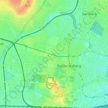
Name: Frederiksberg Municipality topographic map, elevation, terrain.
Location: Frederiksberg Municipality, Capital Region of Denmark, Denmark (55.66650 12.49132 55.69768 12.55734)
Average elevation: 15 m
Minimum elevation: 2 m
Maximum elevation: 39 m
Other topographic maps
Click on a map to view its topography, its elevation and its terrain.
Copenhagen
Denmark > Capital Region of Denmark
Copenhagen, Copenhagen Municipality, Capital Region of Denmark, 1357, Denmark
Average elevation: 9 m
Høje-Taastrup Municipality
Denmark > Capital Region of Denmark
Høje-Taastrup Municipality, Capital Region of Denmark, Denmark
Average elevation: 24 m
Gammel Holte
Denmark > Capital Region of Denmark > Gammel Holte
Gammel Holte, Rudersdal Municipality, Capital Region of Denmark, 2850, Denmark
Average elevation: 33 m
Viberup
Denmark > Capital Region of Denmark > Viberup
Viberup, Tårnby Kommune, Capital Region of Denmark, 2770, Denmark
Average elevation: 1 m
Fredensborg
Denmark > Capital Region of Denmark > Fredensborg
Fredensborg, Fredensborg Municipality, Capital Region of Denmark, 3480, Denmark
Average elevation: 27 m