
Blyde River topographic map
Interactive map
Click on the map to display elevation.
About this map
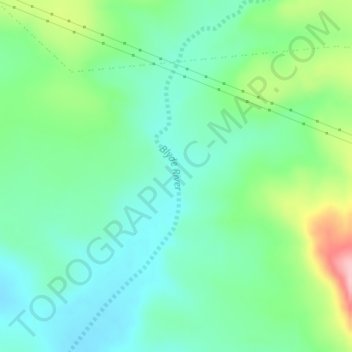
Name: Blyde River topographic map, elevation, terrain.
Average elevation: 695 m
Minimum elevation: 647 m
Maximum elevation: 816 m
Other topographic maps
Click on a map to view its topography, its elevation and its terrain.
Cookhouse
South Africa > Eastern Cape > Sarah Baartman District Municipality > Blue Crane Route Local Municipality
Cookhouse, Blue Crane Route Local Municipality, Sarah Baartman District Municipality, Eastern Cape, South Africa
Average elevation: 669 m
Pearston
South Africa > Eastern Cape > Sarah Baartman District Municipality > Blue Crane Route Local Municipality
Pearston, Blue Crane Route Local Municipality, Sarah Baartman District Municipality, Eastern Cape, 5860, South Africa
Average elevation: 728 m