
Pearston topographic map
Interactive map
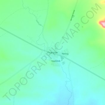
Click on the map to display elevation.
About this map
Name: Pearston topographic map, elevation, terrain.
Average elevation: 728 m
Minimum elevation: 678 m
Maximum elevation: 946 m
Pearston is located about 160 kilometres (100 mi) north of Port Elizabeth, on the banks of the Voël River. It is situated at an altitude of 710 metres (2,330 ft) on the Camdeboo plain. The Coetzeesberge, a spur of the Sneeuberge (a mountain), lie to the north, and the Groot-Bruintjieshoogte lie to the east. Pearston is the meeting point of two regional roads: the R63 from Graaff-Reinet to Somerset East and Cookhouse, and the R337 from Jansenville to Cradock.
Other topographic maps
Click on a map to view its topography, its elevation and its terrain.
Cookhouse
South Africa > Eastern Cape > Sarah Baartman District Municipality > Blue Crane Route Local Municipality
Cookhouse, Blue Crane Route Local Municipality, Sarah Baartman District Municipality, Eastern Cape, South Africa
Average elevation: 669 m
Blyde River
South Africa > Eastern Cape > Sarah Baartman District Municipality > Blue Crane Route Local Municipality
Blyde River, Blue Crane Route Ward 4, Blue Crane Route Local Municipality, Sarah Baartman District Municipality, Eastern Cape, South Africa
Average elevation: 695 m