
Oklahoma County topographic map
Interactive map
Click on the map to display elevation.
About this map
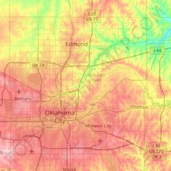
Name: Oklahoma County topographic map, elevation, terrain.
Location: Oklahoma County, Oklahoma, United States of America (35.37688 -97.67402 35.72598 -97.14104)
Average elevation: 354 m
Minimum elevation: 269 m
Maximum elevation: 432 m
Other topographic maps
Click on a map to view its topography, its elevation and its terrain.
Greer County
United States of America > Oklahoma
Greer County, Oklahoma, United States of America
Average elevation: 504 m
Devils Peak
United States of America > Oklahoma
Devils Peak, Muskogee County, Oklahoma, 94434, United States of America
Average elevation: 171 m
Edmond
United States of America > Oklahoma > Edmond
Edmond, Oklahoma County, Oklahoma, United States of America
Average elevation: 340 m