
Johannesburg Ward 87 topographic map
Interactive map
Click on the map to display elevation.
About this map
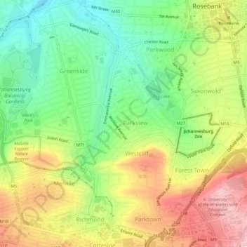
Name: Johannesburg Ward 87 topographic map, elevation, terrain.
Average elevation: 1,661 m
Minimum elevation: 1,562 m
Maximum elevation: 1,783 m
Other topographic maps
Click on a map to view its topography, its elevation and its terrain.
Zoo Lake
RSA > Gauteng > Johannesburg
Zoo Lake, Johannesburg Ward 117, Johannesburg, City of Johannesburg Metropolitan Municipality, Gauteng, 2001, RSA
Average elevation: 1,647 m
Braamfontein Spruit
RSA > Gauteng > Johannesburg
Braamfontein Spruit, Johannesburg, City of Johannesburg Metropolitan Municipality, Gauteng, 2001, RSA
Average elevation: 1,672 m
Johannesburg Ward 60
RSA > Gauteng > Johannesburg
Johannesburg Ward 60, Johannesburg, City of Johannesburg Metropolitan Municipality, Gauteng, 2001, RSA
Average elevation: 1,736 m
Kliprivier
RSA > Gauteng > Johannesburg
Kliprivier, Johannesburg, City of Johannesburg Metropolitan Municipality, Gauteng, 2001, RSA
Average elevation: 1,531 m
Mary Fitzgerald Square
RSA > Gauteng > Johannesburg
Mary Fitzgerald Square, Johannesburg Ward 60, Johannesburg, City of Johannesburg Metropolitan Municipality, Gauteng, 2001, RSA
Average elevation: 1,738 m