
Denpasar topographic map
Interactive map
Click on the map to display elevation.
About this map
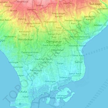
Name: Denpasar topographic map, elevation, terrain.
Location: Denpasar, Bali, Indonesia (-8.75254 115.17319 -8.59084 115.27409)
Average elevation: 23 m
Minimum elevation: -2 m
Maximum elevation: 101 m
Denpasar is located at an elevation of 4 m (13 ft) above sea level. While the total area of 127.78 km² or 2.18% of the total area of Bali Province. From the use of land, 2,768 hectares of land are paddy, 10,001 hectares are dry land, while the remaining land area is 9 hectares.
Other topographic maps
Click on a map to view its topography, its elevation and its terrain.
Sanur Kauh
Sanur Kauh, Denpasar Selatan, Bali, Lesser Sunda Islands, Indonesia
Average elevation: 5 m
Dauh Puri Kangin
Indonesia > Bali > Denpasar > Dauh Puri Kangin
Dauh Puri Kangin, Denpasar Barat, Denpasar, Bali, 80232, Indonesia
Average elevation: 26 m