
Pendleton County topographic map
Interactive map
Click on the map to display elevation.
About this map
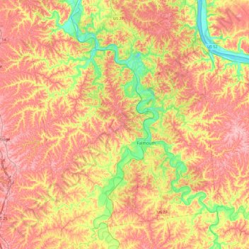
Name: Pendleton County topographic map, elevation, terrain.
Location: Pendleton County, Kentucky, 41040, United States of America (38.52953 -84.53176 38.87470 -84.19530)
Average elevation: 231 m
Minimum elevation: 144 m
Maximum elevation: 302 m
Other topographic maps
Click on a map to view its topography, its elevation and its terrain.
Scenic Lake
United States of America > Kentucky > Henderson
Scenic Lake, Ic-8029F, Henderson, Henderson County, Kentucky, 42420, United States of America
Average elevation: 129 m
Blood River
United States of America > Kentucky
Blood River, Calloway County, Kentucky, 42046, United States of America
Average elevation: 126 m
Cumberland County
United States of America > Kentucky
Cumberland County, Kentucky, United States of America
Average elevation: 237 m
Green County
United States of America > Kentucky
Green County, Kentucky, United States of America
Average elevation: 230 m