
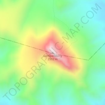
Compassberg topographic map
Interactive map
Click on the map to display elevation.
About this map
Name: Compassberg topographic map, elevation, terrain.
Average elevation: 2,017 m
Minimum elevation: 1,756 m
Maximum elevation: 2,468 m
Other topographic maps
Click on a map to view its topography, its elevation and its terrain.
Groot-Brakrivier
RSA > Eastern Cape > Inxuba Yethemba Local Municipality
Groot-Brakrivier, Inxuba Yethemba Local Municipality, Chris Hani District Municipality, Eastern Cape, RSA
Average elevation: 1,351 m
Mountain Zebra National Park
RSA > Eastern Cape > Inxuba Yethemba Local Municipality
Mountain Zebra National Park, Umgeni Loop - 4x4 Route, Inxuba Yethemba Ward 6, Inxuba Yethemba Local Municipality, Chris Hani District Municipality, Eastern Cape, RSA
Average elevation: 1,230 m
Great Fish River
RSA > Eastern Cape > Inxuba Yethemba Local Municipality
Great Fish River, Inxuba Yethemba Local Municipality, Chris Hani District Municipality, Eastern Cape, RSA
Average elevation: 1,248 m
Grassridge Dam
RSA > Eastern Cape > Inxuba Yethemba Local Municipality
Grassridge Dam, Inxuba Yethemba Ward 6, Inxuba Yethemba Local Municipality, Chris Hani District Municipality, Eastern Cape, RSA
Average elevation: 1,059 m