
North Western Province topographic map
Interactive map
Click on the map to display elevation.
About this map
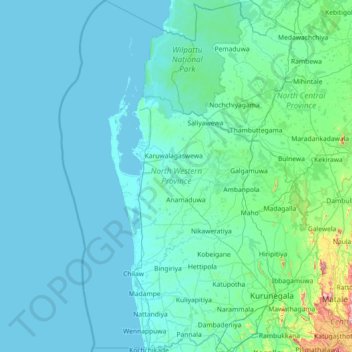
Name: North Western Province topographic map, elevation, terrain.
Location: North Western Province, Sri Lanka (7.25789 79.49072 8.68869 80.57792)
Average elevation: 66 m
Minimum elevation: 0 m
Maximum elevation: 1,167 m
Other topographic maps
Click on a map to view its topography, its elevation and its terrain.
D 12
Sri Lanka > North Western Province > Kurunegala
D 12, Kurunegala, Kurunegala District, North Western Province, Sri Lanka
Average elevation: 138 m