Sullivan County topographic map
Interactive map
Click on the map to display elevation.
About this map
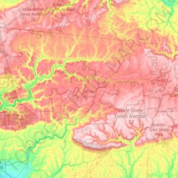
Name: Sullivan County topographic map, elevation, terrain.
Location: Sullivan County, Pennsylvania, United States of America (41.27718 -76.81376 41.59010 -76.21987)
Average elevation: 491 m
Minimum elevation: 144 m
Maximum elevation: 777 m
Elevation ranges from 2593 ft at North Mountain in Davidson Township to 779 ft on Loyalsock Creek at the Lycoming County line. The county is served by Pennsylvania Route 42, Pennsylvania Route 87, Pennsylvania Route 154, Pennsylvania Route 487, and U.S. Route 220. The major rivers in the county are Loyalsock Creek, Little Loyalsock Creek, Muncy Creek, and Fishing Creek. The majority of the land in Sullivan County is forest, but there is some farmland, especially in the northern part of the county. There are numerous river valleys in the southern and western parts of Sullivan County.
Other topographic maps
Click on a map to view its topography, its elevation and its terrain.
Northampton Township
United States of America > Pennsylvania > Northampton Township
Northampton Township, Bucks County, Pennsylvania, United States of America
Average elevation: 69 m
Lutzville
United States of America > Pennsylvania > Lutzville
Lutzville, Bedford County, Pennsylvania, United States of America
Average elevation: 365 m
Beaver County
United States of America > Pennsylvania
Beaver County, Pennsylvania, United States of America
Average elevation: 325 m
Forest County
United States of America > Pennsylvania
Forest County, Pennsylvania, United States of America
Average elevation: 486 m
Wyomissing
United States of America > Pennsylvania > Wyomissing
Wyomissing, Berks County, Pennsylvania, 19610, United States of America
Average elevation: 94 m
Warminster Township
United States of America > Pennsylvania > Warminster Township
Warminster Township, Bucks County, Pennsylvania, 18974, United States of America
Average elevation: 83 m
Dauphin County
United States of America > Pennsylvania
Dauphin County, Pennsylvania, United States of America
Average elevation: 196 m
Clinton County
United States of America > Pennsylvania
Clinton County, Pennsylvania, United States of America
Average elevation: 465 m
Franklin County
United States of America > Pennsylvania
Franklin County, Pennsylvania, United States of America
Average elevation: 304 m
Lancaster County
United States of America > Pennsylvania
Lancaster County, Pennsylvania, United States of America
Average elevation: 158 m
Philadelphia County
United States of America > Pennsylvania
Philadelphia County, Pennsylvania, United States of America
Average elevation: 39 m
Westmoreland County
United States of America > Pennsylvania
Westmoreland County, Pennsylvania, United States of America
Average elevation: 403 m
Urban
United States of America > Pennsylvania > Urban
Urban, Northumberland County, Pennsylvania, 17830, United States of America
Average elevation: 239 m
Balsam
United States of America > Pennsylvania > Balsam
Balsam, Tioga County, Pennsylvania, United States of America
Average elevation: 529 m
Bedford County
United States of America > Pennsylvania
Bedford County, Pennsylvania, United States of America
Average elevation: 491 m
Delaware County
United States of America > Pennsylvania
Delaware County, Pennsylvania, United States of America
Average elevation: 76 m
Lehigh County
United States of America > Pennsylvania
Lehigh County, Pennsylvania, United States of America
Average elevation: 186 m
Allegheny County
United States of America > Pennsylvania
Allegheny County, Pennsylvania, United States of America
Average elevation: 325 m