
Sevier County topographic map
Interactive map
Click on the map to display elevation.
About this map
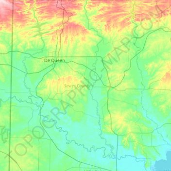
Name: Sevier County topographic map, elevation, terrain.
Location: Sevier County, Arkansas, United States of America (33.75092 -94.47732 34.19251 -93.95696)
Average elevation: 129 m
Minimum elevation: 78 m
Maximum elevation: 295 m
Other topographic maps
Click on a map to view its topography, its elevation and its terrain.
Mount Ida
United States of America > Arkansas > Mount Ida
Mount Ida, Montgomery County, Arkansas, United States of America
Average elevation: 215 m
Hot Springs
United States of America > Arkansas > Hot Springs
Hot Springs, Garland County, Arkansas, United States of America
Average elevation: 172 m
Cleburne County
United States of America > Arkansas
Cleburne County, Arkansas, United States of America
Average elevation: 223 m