
Wicomico County topographic map
Interactive map
Click on the map to display elevation.
About this map
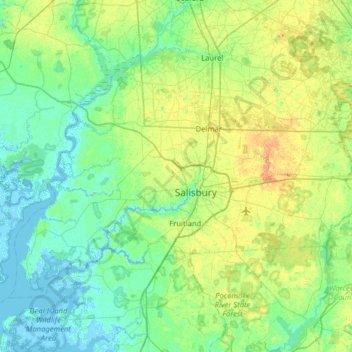
Name: Wicomico County topographic map, elevation, terrain.
Location: Wicomico County, Maryland, United States of America (38.21580 -75.94373 38.56066 -75.30669)
Average elevation: 9 m
Minimum elevation: -4 m
Maximum elevation: 30 m
The county's boundary with Delaware is composed of the Mason-Dixon line and the Transpeninsular Line. The intersection of these two historical lines is the midpoint of the Transpeninsular Line, fixed by Mason and Dixon between 1763 and 1767. The midpoint is located about 8 miles (13 km) northwest of Salisbury, near the center of the Delmarva Peninsula. The county is generally flat, characteristic of the region, with a few small hills in the northeast. The lowest elevation is at sea level and the highest elevation is 98 ft (30 m).
Other topographic maps
Click on a map to view its topography, its elevation and its terrain.
Harford County
United States of America > Maryland
Harford County, Maryland, United States of America
Average elevation: 70 m
Prince George's County
United States of America > Maryland
Prince George's County, Maryland, United States of America
Average elevation: 45 m
Bethesda
United States of America > Maryland > Bethesda
Bethesda, Montgomery County, Maryland, United States of America
Average elevation: 81 m
Bethesda
United States of America > Maryland > Bethesda
Bethesda, Montgomery County, Maryland, 22814, United States of America
Average elevation: 86 m