
Rutland County topographic map
Interactive map
Click on the map to display elevation.
About this map
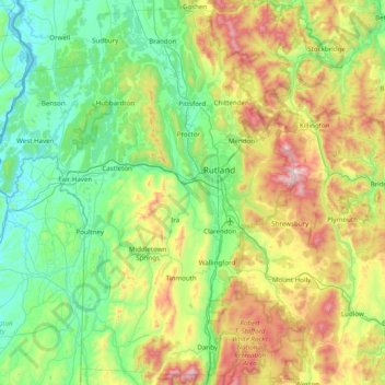
Name: Rutland County topographic map, elevation, terrain.
Location: Rutland County, Vermont, United States of America (43.29055 -73.43133 43.85806 -72.69980)
Average elevation: 363 m
Minimum elevation: 25 m
Maximum elevation: 1,272 m
Other topographic maps
Click on a map to view its topography, its elevation and its terrain.
Caledonia County
United States of America > Vermont
Caledonia County, Vermont, United States of America
Average elevation: 421 m
Chittenden County
United States of America > Vermont
Chittenden County, Vermont, United States of America
Average elevation: 228 m