
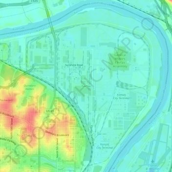
Fairfax topographic map
Interactive map
Click on the map to display elevation.
About this map
Name: Fairfax topographic map, elevation, terrain.
Average elevation: 233 m
Minimum elevation: 218 m
Maximum elevation: 273 m
The district is on the Goose Island river bend (inner concave bank of a meander loop) that had been an island created by an 1880 flood that moved the Missouri River's "main current and the main and principal channel" from around the north, east, and south of the site to a low elevation on the west (Goose Island Chute). By 1907 the state of Kansas had answered a Missouri petition and filed for ownership of the island, which was declared part of Kansas on March 22, 1909, by the United States Supreme Court (in 1940, the USGS mapped the state boundary as a straight north-south line demarcating a small eastern portion of "Fairfax Airport" in Missouri). When flow into the chute was stopped by the Goose Island closing dike, the island became a river bend landform. "The city owned Kansas City Public Levees, the city of Kansas City and the Fairfax Industrial District sponsored a project in which the United States Government constructed flood protection levees and walls around the district, including three pump houses to pump water" with 2 of the houses on the later airfield (the dike extended from Quindaro downstream around Goose Island to the mouth of the Kansas River.) The protected land along the river north of the city ("North Bottoms") was used for farmland which was partly used as an airfield for a 1921 "American Legion air meet".