
Prince George's County topographic map
Interactive map
Click on the map to display elevation.
Prince George's County
Prince George's County lies in the Atlantic coastal plain, and its landscape is characterized by gently rolling hills and valleys. Along its western border with Montgomery County, Adelphi, Calverton and West Laurel rise into the piedmont, exceeding 300 feet (91 m) in elevation.
About this map
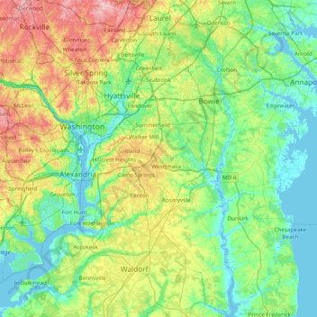
Name: Prince George's County topographic map, elevation, terrain.
Location: Prince George's County, Maryland, United States of America (38.53548 -77.08300 39.13177 -76.66929)
Average elevation: 45 m
Minimum elevation: -4 m
Maximum elevation: 173 m