
Chatham County topographic map
Interactive map
Click on the map to display elevation.
Chatham County
The county lies totally within the Piedmont physiographic region. The topography of the county is generally gently rolling with several higher hills rising above the general terrain. One of these hills, Terrells Mountain, on the Orange County line is the transmitter site for several radio and TV stations for the Raleigh-Durham market, including WUNC-TV 4, WDCG (G105), WNCB (B93.9), and WUNC 91.5 FM (NC Public Radio).
About this map
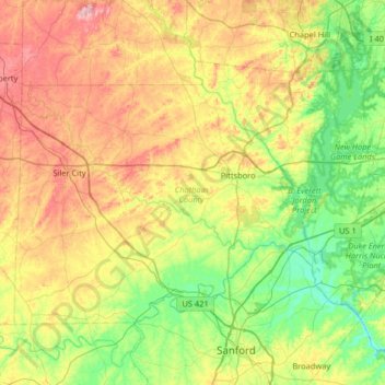
Name: Chatham County topographic map, elevation, terrain.
Location: Chatham County, North Carolina, United States of America (35.51506 -79.55579 35.87682 -78.90607)
Average elevation: 132 m
Minimum elevation: 39 m
Maximum elevation: 296 m
Other topographic maps
Click on a map to view its topography, its elevation and its terrain.