
Kamrup Metropolitan topographic map
Interactive map
Click on the map to display elevation.
About this map
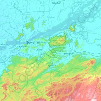
Name: Kamrup Metropolitan topographic map, elevation, terrain.
Location: Kamrup Metropolitan, Assam, India (25.99685 91.56055 26.27347 92.17576)
Average elevation: 216 m
Minimum elevation: 41 m
Maximum elevation: 1,073 m
Other topographic maps
Click on a map to view its topography, its elevation and its terrain.
Guwahati
Professor Abani Kumar Bhagawati of Gauhati University stated that since before there were sufficient wetlands to absorb rainwater and channels to carry excess water to the Brahmaputra, the city did not experience floods. However, human interference has disrupted the natural topography, leading to the current…
Average elevation: 113 m