
Vleesbaai topographic map
Interactive map
Click on the map to display elevation.
About this map
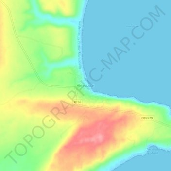
Name: Vleesbaai topographic map, elevation, terrain.
Location: Vleesbaai, George, Western Cape, South Africa (-34.30972 21.89278 -34.26972 21.93278)
Average elevation: 37 m
Minimum elevation: -2 m
Maximum elevation: 106 m
Other topographic maps
Click on a map to view its topography, its elevation and its terrain.