
Koh Kong topographic map
Interactive map
Click on the map to display elevation.
About this map
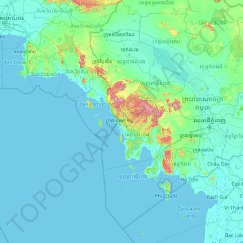
Name: Koh Kong topographic map, elevation, terrain.
Location: Koh Kong, Cambodia (9.08134 100.42580 14.28134 105.62580)
Average elevation: 53 m
Minimum elevation: -2 m
Maximum elevation: 1,678 m
Other topographic maps
Click on a map to view its topography, its elevation and its terrain.
Sangkat Ponsang
Sangkat Ponsang, Phnom Penh, 121105, Cambodia
Average elevation: 18 m
Phnom Penh
Cambodia > Phnom Penh > Phnom Penh
Phnom Penh, Khan Daun Penh, Phnom Penh, 11213, Cambodia
Average elevation: 10 m
Sangkat Niroth
Sangkat Niroth, Phnom Penh, 121203, Cambodia
Average elevation: 10 m
Sihanoukville
Cambodia > Khaet Preah Sihanouk > Krong Preah Sihanouk > Sihanoukville
Sihanoukville, Krong Preah Sihanouk, Khaet Preah Sihanouk, 18000, Cambodia
Average elevation: 14 m
Mekong River
Mekong River, Koki commune, Kandal, 12110, Cambodia
Average elevation: 8 m