
Varese topographic map
Interactive map
Click on the map to display elevation.
About this map
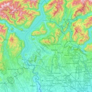
Name: Varese topographic map, elevation, terrain.
Location: Varese, Lombardy, Italy (45.55831 8.55225 46.12226 9.06630)
Average elevation: 520 m
Minimum elevation: 142 m
Maximum elevation: 2,252 m
Other topographic maps
Click on a map to view its topography, its elevation and its terrain.
Valle Salimbene
Italy > Lombardy > Pavia > Valle Salimbene
Valle Salimbene, Pavia, Lombardy, 27010, Italy
Average elevation: 67 m
Lake Maggiore
Italy > Lombardy > Castelveccana
Lake Maggiore, Via dei Caduti per la Patria, Cascina Girolo, Castelveccana, Comunità Montana Valli del Verbano, VA, Lombardy, 28823, Italy
Average elevation: 655 m
Bergamasque Alps and Prealps
Italy > Lombardy > Oltre il Colle
Bergamasque Alps and Prealps, Oltre il Colle, Comunità Montana della Valle Brembana, BG, Lombardy, Italy
Average elevation: 977 m
Lago di Lei
Lago di Lei, Mottalla - Passo dell'Angeloga, Alpe Mottala, Piuro, Comunità Montana della Valchiavenna, SO, Lombardy, Italy
Average elevation: 2,318 m