
Cotopaxi topographic map
Interactive map
Click on the map to display elevation.
About this map
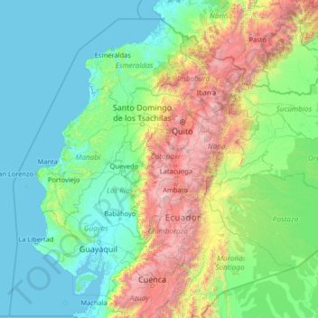
Name: Cotopaxi topographic map, elevation, terrain.
Location: Cotopaxi, Ecuador (-3.42685 -81.49378 1.77315 -76.29378)
Average elevation: 816 m
Minimum elevation: -2 m
Maximum elevation: 5,883 m
Other topographic maps
Click on a map to view its topography, its elevation and its terrain.
Loja
Loja is located in a high Andean valley at an elevation of 7,300 feet (2,225 m). It had a population of 448,966 inhabitants at the 2010 census. It is recognized as being a friendly and pleasant city. This was demonstrated when Loja, both the provincial capital and one of the oldest cities in Ecuador, won a…
Average elevation: 1,227 m
Tungurahua
Generally though, Tungurahua experiences temperatures between 14 and 17 degree Celsius in the day-time, with cooler nights. At higher altitudes, conditions are much colder. Despite the area being near the Equator, mountains such as Carihuayrazo and Chimborazo are covered in snow for much of the year.
Average elevation: 3,118 m
San Salvador
Ecuador > Galápagos > Cantón Santa Cruz
The city is located in the Boquerón Volcano Valley, a region of high seismic activity. The city's average elevation is 659 meters (2,162 feet) above sea level, but ranges from a highest point of 1,186 meters (3,891 feet) above sea level to a lowest point of 596 m (1,955 ft) above sea level.
Average elevation: 81 m