
Jalandhar topographic map
Interactive map
Click on the map to display elevation.
About this map
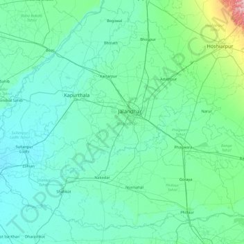
Name: Jalandhar topographic map, elevation, terrain.
Location: Jalandhar, Punjab, India (30.96609 75.07614 31.61813 75.95809)
Average elevation: 242 m
Minimum elevation: 211 m
Maximum elevation: 574 m
Other topographic maps
Click on a map to view its topography, its elevation and its terrain.
Amritsar
India > Punjab > Amritsar I Tahsil
Amritsar is located at 31°38′N 74°52′E / 31.63°N 74.87°E / 31.63; 74.87 with an average elevation of 234 metres (768 ft) in the Majha region of the state of Punjab in North India and lies about 15 miles (24 km) east of the border with Pakistan. Administrative towns includes Ajnala, Attari,…
Average elevation: 231 m
Ludhiana
India > Punjab > Ludhiana (West) Tahsil
Ludhiana is located at 30°54′N 75°51′E / 30.9°N 75.85°E / 30.9; 75.85. It has an average elevation of 244 metres (801 ft). Ludhiana City, to its residents, consists of the Old City and the New City. The new city primarily consists of the Civil Lines area which was historically known as the…
Average elevation: 247 m