
Uttara Kannada topographic map
Interactive map
Click on the map to display elevation.
About this map
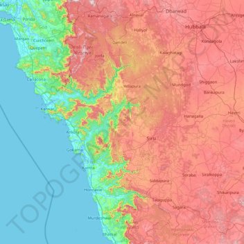
Name: Uttara Kannada topographic map, elevation, terrain.
Location: Uttara Kannada, Karnataka, India (13.92485 74.05439 15.52405 75.10367)
Average elevation: 364 m
Minimum elevation: -2 m
Maximum elevation: 1,035 m
The district's high rainfall supports lush forests, which cover approximately 70% of the district. The Malabar Coast moist forests ecoregion lies in a narrow strip between the Arabian Sea and the foothills of the Western Ghats up to 250 meters elevation. These forests have been almost completely converted to agriculture and teak plantations. The North Western Ghats moist deciduous forests cover the Sahyadris from 250 to 1000 meters elevation. Many trees shed leaves in the drier months. Above 1000 meters elevation lie the evergreen North Western Ghats montane rain forests. Anshi National Park near Dandeli, preserves approximately 250 square kilometres (97 sq mi) of semi-evergreen forest, which is home to the tiger, black panther, leopard cat, gaur, Asian elephant, sambar and a range of birds and reptiles. Dandeli Wildlife Sanctuary protects 834 square kilometres (322 sq mi) of semi-evergreen and bamboo forest in the watershed of the Kali river and its tributaries, the Kaneri and Nagajhari. Wroughton's free-tailed bat (Otomops wroughtoni) is endemic to the forests of Bhimgad Wildlife Sanctuary.
Other topographic maps
Click on a map to view its topography, its elevation and its terrain.
Bengaluru
India > Karnataka > Bangalore North
Bengaluru, Bangalore North, Bengaluru Urban, Karnataka, India
Average elevation: 886 m
Bangalore South
Bangalore South, Bengaluru Urban, Karnataka, India
Average elevation: 847 m
Hassan
India > Karnataka > Hasana taluk
Hassan, Hasana taluk, Hassan district, Karnataka, 573201, India
Average elevation: 949 m
Bengaluru
India > Karnataka > Bangalore North > Bengaluru
Bengaluru, Bangalore North, Bangalore Urban, Karnataka, 560001, India
Average elevation: 879 m
Vasana
India > Karnataka > Harihara taluku > Vasana
Vasana, Harihara taluku, Davanagere District, Karnataka, 581119, India
Average elevation: 543 m
Garugadahalli
India > Karnataka > Garugadahalli
Garugadahalli, Kaduru taluk, Chikkamagaluru district, Karnataka, India
Average elevation: 726 m
Kalaburagi
India > Karnataka > Kalaburagi
Kalaburagi, Gulbarga taluku, Kalaburagi district, Karnataka, 585101, India
Average elevation: 465 m
Hadonahalli
India > Karnataka > Hadonahalli
Hadonahalli, Doddaballapura taluk, Bangalore Rural, Karnataka, India
Average elevation: 913 m
Tadiandamol
Tadiandamol, Madikeri taluku, Kodagu, Karnataka, India
Average elevation: 1,322 m
Baba Budangiri
India > Karnataka > Chikkamagaluru
Baba Budangiri, Chikkamagaluru, Chikkamagaluru taluku, Chikkamagaluru district, Karnataka, 577101, India
Average elevation: 1,628 m
Kumara Parvatha
Kumara Parvatha, Somawarpet taluk, Kodagu, Karnataka, India
Average elevation: 1,227 m
Krishna River
Krishna River, Shahapura taluku, Yadagiri district, Karnataka, 412803, India
Average elevation: 413 m
Chikmagalur
Chikmagalur, Chikkamagaluru district, Karnataka, India
Average elevation: 652 m
Hegganahalli
Hegganahalli, Dasarahalli Zone, Bengaluru, Bangalore Urban, Karnataka, India
Average elevation: 907 m
Sampangiram Nagar Ward
Sampangiram Nagar Ward, East Zone, Bengaluru, Bangalore Urban, Karnataka, India
Average elevation: 916 m