
Islamabad Capital Territory topographic map
Interactive map
Click on the map to display elevation.
About this map
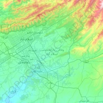
Name: Islamabad Capital Territory topographic map, elevation, terrain.
Location: Islamabad Capital Territory, Pakistan (33.46810 72.81760 33.80328 73.37488)
Average elevation: 697 m
Minimum elevation: 381 m
Maximum elevation: 2,190 m
The climate of Islamabad has a humid subtropical climate (Köppen: Cwa), with five seasons: Winter (November–February), Spring (March and April), Summer (May and June), Rainy Monsoon (July and August) and Autumn (September and October). The hottest month is June, where average highs routinely exceed 38 °C (100.4 °F). Wettest month is July, with heavy rainfalls and evening thunderstorms with the possibility of cloudburst and flooding. Coolest month is January. Islamabad's micro-climate is regulated by three artificial reservoirs: Rawal, Simli, and Khanpur Dam. Last one is located on the Haro River near the town of Khanpur, about 40 kilometres (25 mi) from Islamabad. Simli Dam is 30 kilometres (19 mi) north of Islamabad. 220 acres (89 ha) of the city consists of Margalla Hills National Park. Loi Bher Forest is situated along the Islamabad Highway, covering an area of 1,087 acres (440 ha). Highest monthly rainfall of 743.3 millimetres (29.26 in) was recorded during July 1995. Winters generally feature dense fog in the mornings and sunny afternoons. In the city, temperatures stay mild, with snowfall over the higher elevations points on nearby hill stations, notably Murree and Nathia Gali. The temperatures range from 13 °C (55 °F) in January to 38 °C (100 °F) in June. The highest recorded temperature was 46.6 °C (115.9 °F) on 23 June 2005 while the lowest temperature was −6 °C (21.2 °F) on 17 January 1967. The city has "recorded" snowfall. On 23 July 2001, Islamabad received a record breaking 620 millimetres (24 in) of rainfall in just 10 hours. It was the heaviest rainfall in Islamabad in the past 100 years and the highest rainfall in 24 hours as well.
Other topographic maps
Click on a map to view its topography, its elevation and its terrain.
Goth Halepoto
Pakistan > Sindh > Matiari District
Goth Halepoto, Matiari Taluka, Matiari District, Hyderabad Division, Sindh, Pakistan
Average elevation: 22 m
Faisalabad
Pakistan > Punjab > Faisalabad
Faisalabad, Faisalābād District, Punjab, 38000, Pakistan
Average elevation: 184 m
Bahawalpur
Pakistan > Punjab > Bahawalpur
Bahawalpur, Bahāwalpur District, Punjab, 63100, Pakistan
Average elevation: 118 m
Pir Pai
Pakistan > Khyber Pakhtunkhwa > Pir Pai
Pir Pai, Peshāwar District, Khyber Pakhtunkhwa, Pakistan
Average elevation: 316 m
Istor-o-Nal
Istor-o-Nal, Chitrāl District, Khyber Pakhtunkhwa, Pakistan
Average elevation: 6,853 m
Kunyang Chhish
Kunyang Chhish, Gilgit District, Gilgit-Baltistan, Pakistan
Average elevation: 6,837 m
Nanga Parbat
Nanga Parbat, Diāmir District, Gilgit-Baltistan, Pakistan
Average elevation: 7,086 m
Saraghrar I
Saraghrar I, Chitrāl District, Khyber Pakhtunkhwa, Pakistan
Average elevation: 6,780 m
Haramosh
Haramosh, Diāmir District, Gilgit-Baltistan, Pakistan
Average elevation: 6,476 m
Masherbrum
Masherbrum, Baltistān District, Gilgit-Baltistan, Pakistan
Average elevation: 6,469 m
Gasherbrum I
Gasherbrum I, Baltistān District, Gilgit-Baltistan, Pakistan
Average elevation: 7,177 m
K2
K2, Baltistān District, Gilgit-Baltistan, Pakistan
Average elevation: 7,490 m
Tirich Mir
Tirich Mir, Chitrāl District, Khyber Pakhtunkhwa, Pakistan
Average elevation: 6,886 m
Biafo Glacier
Biafo Glacier, Baltistān District, Gilgit-Baltistan, Pakistan
Average elevation: 4,646 m
Laila Peak
Laila Peak, Baltistān District, Gilgit-Baltistan, Pakistan
Average elevation: 5,066 m
Nankana Sahib
Pakistan > Punjab > Nankana Sahib
Nankana Sahib, Shekhūpura District, Punjab, Pakistan
Average elevation: 195 m
Diran
Pakistan > Gilgit-Baltistan > Gilgit
Diran, Gilgit, Gilgit District, Gilgit-Baltistan, Pakistan
Average elevation: 6,311 m
Panmah Glacier
Panmah Glacier, Baltistān District, Gilgit-Baltistan, Pakistan
Average elevation: 4,966 m
Peshāwar District
Peshāwar District, Khyber Pakhtunkhwa, Pakistan
Average elevation: 684 m
Chitral
Pakistan > Khyber Pakhtunkhwa > Chitrāl District
Chitral, Chitral Tehsil, Lower Chitral District, Chitrāl District, Malakand Division, Khyber Pakhtunkhwa, Pakistan
Average elevation: 2,982 m
Kanjut Sar I
Kanjut Sar I, Baltistān District, Gilgit-Baltistan, Pakistan
Average elevation: 6,762 m
Baltoro Glacier
Baltoro Glacier, Baltistān District, Gilgit-Baltistan, Pakistan
Average elevation: 5,349 m
Vigne Glacier
Vigne Glacier, Baltistān District, Gilgit-Baltistan, Pakistan
Average elevation: 5,428 m
Chenab River
Chenab River, Gujrānwāla District, Punjab, 35460, Pakistan
Average elevation: 507 m
Khyber Pakhtunkhwa
Khyber Pakhtunkhwa, Pakistan
Average elevation: 2,135 m
Batura Glacier
Batura Glacier, Gilgit District, Gilgit-Baltistan, Pakistan
Average elevation: 4,775 m
Gasherbrum III
Gasherbrum III, Baltistān District, Gilgit-Baltistan, Pakistan
Average elevation: 7,082 m
Gasherbrum V
Gasherbrum V, Baltistān District, Gilgit-Baltistan, Pakistan
Average elevation: 6,267 m
Battagram District
Battagram District, Khyber Pakhtunkhwa, 21040, Pakistan
Average elevation: 2,024 m