
Bolikhamsai topographic map
Interactive map
Click on the map to display elevation.
About this map
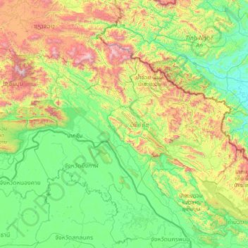
Name: Bolikhamsai topographic map, elevation, terrain.
Location: Bolikhamsai, Laos (17.86978 102.81023 19.12116 105.25881)
Average elevation: 528 m
Minimum elevation: 7 m
Maximum elevation: 2,779 m
Bolikhamsai province has a rugged terrain, with large boulders and streams. Its elevation ranges from 140–1,588 metres (459–5,210 ft). The principal river is the Nam Kading, meaning 'water like a bell', a tributary of the Mekong; its catchment covers about 92% of the provincial area. The other main rivers are the Nam Muan, Nam Sat, and the Nam Tek. Waterfalls of note include the Tad Leuk, Tad Xay and Tad Xang. The longest mountain range in the province is the Phou Louang range, running to the southwest, the Phou Ao range to the southeast; the Thalabat range to the northwest, and the Pa Guang range to the northeast. In Khamkheuth District, there is karst limestone scenery, which is allegedly the largest formation of its type in Southeast Asia. The many rock pinnacles have formed stone forest similar to limestone outcrops in southern China.
Other topographic maps
Click on a map to view its topography, its elevation and its terrain.
Vientiane Capital
Laos > Vientiane Prefecture > Chanthabuly District
Vientiane Capital, Chanthabuly District, Vientiane Prefecture, Laos
Average elevation: 187 m
Sibounheuang
Laos > Vientiane Prefecture > Sibounheuang
Sibounheuang, Vientiane Capital, Chanthabuly District, Vientiane Prefecture, 01009, Laos
Average elevation: 171 m