
Hudson County topographic map
Interactive map
Click on the map to display elevation.
About this map
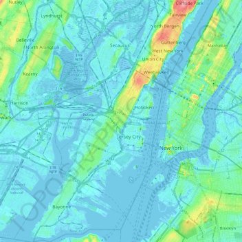
Name: Hudson County topographic map, elevation, terrain.
Location: Hudson County, New Jersey, United States of America (40.64215 -74.16609 40.82357 -73.98488)
Average elevation: 12 m
Minimum elevation: -9 m
Maximum elevation: 98 m
The topography is marked by the New Jersey Palisades in the north with cliffs overlooking the Hudson to the east and less severe cuesta, or slope, to the west. They gradually level off to the southern peninsula, which is coastal and flat. The western region, around the Hackensack and Passaic is part of the New Jersey Meadowlands. Much of the land along the county's extensive shoreline and littoral zone was created by land reclamation.
Other topographic maps
Click on a map to view its topography, its elevation and its terrain.
Ocean County
United States of America > New Jersey
Ocean County, New Jersey, United States of America
Average elevation: 15 m
West Windsor Township
United States of America > New Jersey > West Windsor Township
West Windsor Township, Mercer County, New Jersey, 08550, United States of America
Average elevation: 28 m
Trenton
United States of America > New Jersey > Trenton
Trenton, Mercer County, New Jersey, United States of America
Average elevation: 19 m
Camden
United States of America > New Jersey > Camden
Camden, Camden County, New Jersey, United States of America
Average elevation: 7 m